Modern Smartphones such as the iPhone, Samsung Galaxy or Sony Xperia are amazing mobile devices, minicomputers in our pockets. No longer just a device to make or receive a phone call, or send a text message. Major advances in performance of the phone hardware have enabled greater functionality such as excellent photos and video capture and there has been huge progress too in the sophistication of the software or apps currently available.
So what do I mean by Smartphone Navigation (SN)? Many people who have a Smartphone will have opened an app such as Google Maps, to find out where they are and to navigate across a town or city to a particular location. This is one of the most popular forms of SN.
One further step that can be taken in Google Maps is to obtain directions (with suggested alternatives) to get you from your current location to some desired address. The following screenshots will look very familiar.
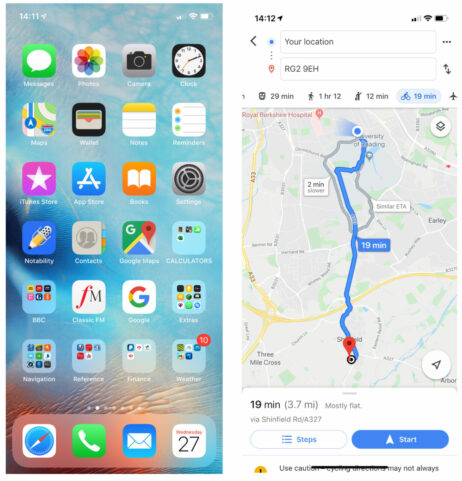
For many of us and for many situations, the routes that are suggested are great and all we need. So when we click the Start button we receive audible turn by turn instructions while on the motorbike or walking, making progress to get to our destination.
All of this is taking place on the device that you have in your pocket most of the time and that you use for a number of other things, such as phoning friends or checking the diary or sending emails or WhatsApp messages. If you can do all this and more on your Smartphone, is there any need to have a dedicated navigation device such as the BMW Navigator V/VI where the default route planning software is Garmin Basecamp? I will discuss this in detail later in this article and finish with the pros and cons of using one device. But first I will look at dedicated route planning apps for your Smartphone.
An app such as Google Maps (there are others such as Maps on iOS) is great for simple SN, but what do you do when you want to plan more detailed routes over several days that takes one beyond what Google Maps can provide? There are several good alternatives to Google Maps but there may be a charge for using them. One app I have used and like very much is MyRoute-app (MRA). It is simple to use and offers many significant advantages over the long-established Basecamp.
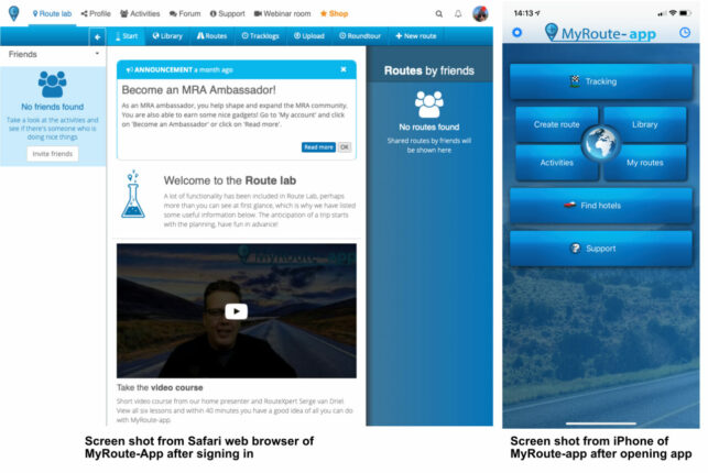
This app is browser based on the desktop and can be signed into using Safari, Chrome or Firefox and appears as an app on an iPhone or iPad, so you can use any device to sign into it. This means it can be used on Windows or a Mac. Basecamp is currently limited only to use on a desktop or laptop and is not browser based.
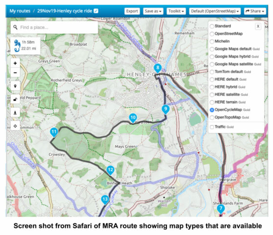
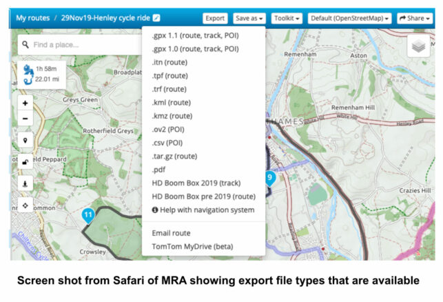
MRA is like all route creating apps in that you use waypoints to create the route. When you subscribe to MRA you are in effect paying for the licensing fee that covers the use of Google Maps, HERE (the map used by Garmin), TomTom, OpenCycle Maps is also provided as well as OpenSteetMap, Michelin map and OpenTopo Map. Once you are happy with the route, connect your device to your desktop/laptop using the appropriate USB cable. MRA has all the important file formats in which you can export the route to a navigation device or export via email.
A powerful feature of MRA is that it is possible to compare the route created with the TomTom map with HERE or GoogleMaps. The algorithms used by these programs are slightly different and depending on where the waypoints are placed, the route may differ between the maps. It is possible to overlay the route across three maps to see how it varies. Before exporting the route, it is possible to harmonise the route across maps. This means that it is then possible to export a route to a Garmin device or Navigator V/VI, knowing that the route will be the same as that imported on a TomTom device. This of course means that for a group of bikers that have either TomTom or Navigator V/VI devices, everyone will have an identical route to follow, rather than some bikes going off one way at a T junction and the other group going another way.
Another useful difference with MRA compared with Basecamp is the ability to share routes easily with others. The routes that you make are either private or can be made public. It is possible for a biker to create a Group and invite other members to join the group meaning that everyone in the group has access to all the public routes of the Group administrator, once they have signed in to MRA. This would be very useful for Short Notice Rides for example, where each biker would call up the appropriate shared route for that ride. Having the routes set up as public routes means that any biker can go to the library section of MRA to see available routes made by others and then use that route themselves.
A further great feature I use a lot, is the ability with a couple of clicks, to go to Street View in GoogleMaps from within MRA, so I can see how tricky a particular junction might be. This means you do not have to have GoogleMaps open as a separate program on the desktop as you would when using Basecamp. GoogleMaps is one of the maps available to you directly in MRA. You can also create a waypoint from map coordinates.
I have focussed a lot on MRA and it is interesting to note that the Thames Vale Advanced Motorcycle group (about 1000 members) has adopted MRA as their standard route mapping software. They have been able to get a group discount of 30% on the annual membership fee from MRA. I imagine it would be possible to do the same for the whole of the BMW Motorcycle Club.
There are a lot of other route making apps out there, for example Rizer, Rever (USA orientated) and Calimoto. As far as I can see MRA comes out on top for ease of use, features offered and cost.
I mentioned earlier about having just one device on the motorbike, that is to say just a SmartPhone and not a Navigator V/VI, or TomTom. My experience to date with MRA and using my iPhone, indicates this is possible. I have toured, Wales, Scotland, the Pyrenees and western France using MRA routes on my iPhone. On an odd occasion I have run into trouble where there is a poor phone signal, for if MRA needs to go away and get data to update the route, then you might be in trouble. However, with the appropriate map downloaded onto your Smartphone, it is possible to use MRA offline and then your device is working like a Nav V/VI or TomTom.
To use an MRA created route on a SmartPhone, there also needs to be an app called Navigation. On starting up Navigation all of the routes created in MRA are available and once the Navigate button is tapped the SmartPhone works as a navigation device, providing the route map and turn by turn audio instructions. This approach avoids the need to export the map created in MRA to a Garmin or TomTom device. Some bikers I have talked to like to continue to use their TomTom for example and use another app on their SmartPhone, such as Waze, a program that alerts you to on route features, such as potholes, speed cameras, road works. Bikers/drivers who come across a pothole can mark its place by tapping a button on Waze and the location is immediately uploaded to all users.
To summarise, creating complex routes using MRA is simpler than Basecamp, no need to worry about shaping points or via points and doing so is not confined to a laptop or desktop. There is no sign currently that Basecamp is going to become web based like MRA. A suggested strategy could be to start using MRA to plan your routes and then export the route to your Nav V/VI or TomTom so that you have the familiarity of your device guiding you while riding. Over time you might try to use your Smartphone and find that one device is enough. However having the TomTom, Nav V/VI in reserve might be handy if you lose or damage your phone.
Originally posted 2019-12-10 22:52:52.


You must be logged in to post a comment.